

Tuesday, December 4, 2012
Tuolumne climate change sensitivity
Monday, December 3, 2012
October stakeholder meeting materials
The agenda and presentations from the October stakeholder meeting are now available.
Sunday, December 2, 2012
Clavey confluence timelapse
This past spring, UC Davis researchers installed time lapse cameras, water stage recorders, and temperature monitoring equipment in both the mainstem Tuolumne River (regulated by Hetch Hetchy Project facilities - particularly Holm Powerhouse) and the Clavey River (an unregulated tributary to the Tuolumne) near their confluence. Video gurus at UC Davis then layered the time lapse video, stage, and temperature data of both rivers, providing a visual comparison of temperature and hydrology dynamics in the regulated and unregulated streams. This work is part of a larger UC Davis effort to learn more about how tributaries and stream confluences affect hydrology and geomorphology. Watch the video in HD on Vimeo for best effect, and to learn more about how the video and data were compiled.
Time Lapse Hydrography - Tuolumne and Clavey Rivers 2012 with Temperatures from Center for Watershed Sciences on Vimeo.
Tuesday, May 29, 2012
Pacific Northwest Watershed Managers group tour
From April 30 to May 4, 2012, the SFPUC hosted the Pacific Northwest Watershed Managers (PNWM) group on a tour of the SFPUC water system, from the San Francisco Peninsula to Hetch Hetchy. The group consists of watershed managers from the six largest unfiltered municipal water supply systems along the Pacific coast of North America, and was created to facilitate the exchange of information about programs,
policies, and best management practices. Materials discussed during the tour are available for viewing and download below.
Please note: we use Google Docs to host files online. Smaller files will be previewed in Google Docs, while larger files can only be downloaded. If a file is displayed in Google Docs, but you'd rather download it, go to the "File" menu and select "Download original". In some cases, Google can't preview the file and will say so; choose "Download" to download the file to your computer. If you are having issues, email wsears@sfwater.org.
Tour handouts and presentations
Alameda Creek tour itinerary
Alameda Creek handouts (several SFPUC presenters)
Tuolumne River tour itinerary
Tuolumne River handouts (Bill Sears, SFPUC)
Hetch Hetchy Project operations overview (Adam Mazurkiewicz, SFPUC)
Upper Tuolumne River Ecosystem Project overview (Bill Sears, SFPUC)
Alameda Creek historical ecology overview (Robin Grossinger, Bronwen Stanford, SFEI)
Wednesday, April 25, 2012
Spring snowmelt management: a frog year?
As the spring unfolds and late rains continue to fall, it's clear this is not the dry year it could have been. However, the rains came too late to make up for the mostly precipitation-free winter. The good news is this provides another opportunity to test the snowmelt management strategies being developed for O'Shaughnessy Dam to benefit the Poopenaut Valley wetlands and the rest of the Tuolumne River ecosystem. This year, operational tests will focus on managing available snowmelt spill to fill the Poopenaut Valley pond while also providing good conditions for foothill yellow-legged frogs. Dry years provide the best opportunity to benefit the small foothill yellow-legged frog population present upstream of Early Intake. In wetter years the upper mainstem Tuolumne features higher and more variable snowmelt flows that can last into the summer. Wet year high flows can delay egg-laying or scour egg clutches, and are challenging for egg and tadpole development, as they likely were even under natural conditions. Dry year snowmelt spill flows are designed to peak early and provide more stable flow conditions for egg laying and tadpole development. Filling the Poopenaut pond will provide good conditions for benthic macroinvertebrates, chorus frogs, garter snake, bats, and other wildlife that depend on the pond ecosystem over the remainder of spring and into early summer.
Flow releases from O'Shaughnessy Dam will remain at current levels through Friday, April 27 to accomodate biological monitoring work, but will increase on Saturday to 200 cfs and possibly slightly higher thru Monday. Flows will ramp up on Tuesday, with a peak on Wednesday (May 2) of 4100 cfs. The peak will be timed for mid-day Wednesday to allow the highest flow to pass boaters in the Lumsden reach went they are off the water in the evening and allow for observation at O’Shaughnessy Dam and the Poopenaut Valley overlook during daylight. The current plan is to ramp down to 250 cfs by Thursday afternoon; however flows may stay higher if needed to manage snowmelt inflows.
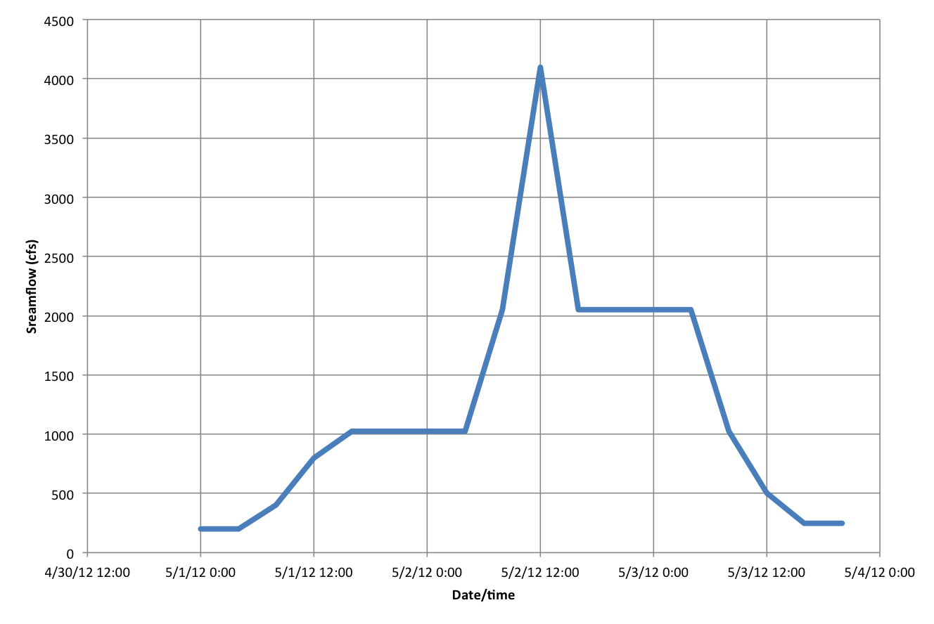 |
| Planned snowmelt management hydrograph. |
Monday, March 26, 2012
Poopenaut Valley groundwater study
 |
| Poopenaut Valley |
Modeling of the groundwater–wetland system suggests that inundation of surface soils is the most effective mechanism for developing wetland conditions, although an elevated water table helps to extend the duration of soil saturation. Results of the study will be incorporated into flow recommendations being developed for O'Shaughnessy Dam by UTREP.
Looking Downstream 2009 & 2010 reports available
We've just uploaded NPS update reports on ecological monitoring in the Poopenaut Valley for 2009 and 2010. In 2009 and 2010, NPS scientists continued to conduct extensive monitoring of wetland and meadow hydrology, birds, vegetation, and benthic macroinvertebrates. New work in these two reports includes groundwater modeling by UC Santa Cruz and bat surveys conducted by NPS.
Wednesday, March 21, 2012
Spring stakeholder meeting
The next meeting of the Upper Tuolumne River Stakeholder Group is set for April 13, 2012 from 11am - 2:30pm at the Moccasin Administration Building (map). View or download the agenda here. If you plan to attend the Stakeholder Group meeting, please email Bill Sears at wsears@sfwater.org.